Tuesday, February 26, 2013

Visible Cities


Cambridge, February 26, 2013

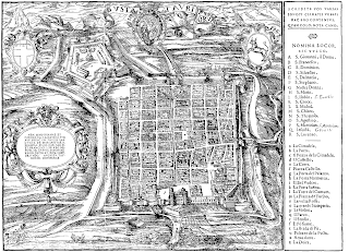
Yesterday, Bom Chinburi--one of the students in my "Bauhaus & the City" studio at RISD--did a wonderful impersonation of Paul Klee, and he mentioned the influence that the French painter Robert Delaunay had on Klee.  I never thought about this, but Klee explicitly made the connection between his paintings of squares and grids with Delaunay's compositions of circles and arcs.


It made me think of Italo Calvino, when he writes about Turin and Milan, a comparison that seemed to be quite often in his mind, at least since 1945 when he chose between the two cities and became an adopted Turinese.  In a 1985 interview Calvino talks about "... the incompatibility between the grid pattern of one and the circular plan of the other..."  It is as if he believed that the contrasting geometries were emblematic of the two cities, "... euphoric and extroverted Milan, as opposed to methodical and cautious Turin..."


But there had to be a twist, of course.  Someone like Calvino wouldn't have settled for the discipline of Turin's grid if he didn't see a bigger payoff, don't you think?  In a little note written 25 years earlier he remarked that "Turin is a city which entices the writer towards vigour, linearity, style.  It encourages logic, and through logic it opens the way towards madness."

I suspect that Klee would have agreed.

Monday, February 25, 2013

Cleopatra in London & New York


Providence, February 25, 2013

Sometime around 1450 BC the Egyptian Pharaoh Thutmose III had two large obelisks carved from Aswan red granite.  Fast forward almost 3500 years and you'll find one of the obelisks in London and the other in New York.  How come?

Once completed, the obelisks were ferried down the Nile and erected in Heliopolis, near present-day Cairo.  A couple centuries later Ramesses II added their characteristic hieroglyphic inscriptions.  Another 13 centuries and Augustus Caesar had the pair brought farther north, to Alexandria, where they were re-erected in the Caesareum, a Roman temple.  Then in the early 19th century, the Egyptian ruler Muhamad Ali, offered one of the obelisks to the United Kingdom, but it would take another sixty years--and a great deal of trials and tribulations--for the more than 200-ton gift to reach London.  At about the same time, Muhamad Ali's grandson, Isma'il Pasha, gave the other obelisk to the city of New York.


Due to their Roman associations, both monuments are known as "Cleopatra's Needle".  Separated after more than three millenniums, the twin needles found themselves in very different locations, one at the edge of a river and the other in the middle of a park.  When the initial proposal of locating it in front of the House of Parliament was rejected, the London needle was placed along the Thames, as a major feature of the embankment, complete with two bronze sphinxes at its side.  On the other side of the Atlantic, the New York needle took two months to cross Manhattan, from the harbor all the way to Central Park, where it was erected behind the Metropolitan Museum.

In a way, the stories of their travels and relocations are as interesting as the monuments themselves, as if they encapsulated historic epics of complex politics and elaborate technologies.  And all to move these huge chunks of stone.


Friday, February 22, 2013

Obelisks Everywhere!


Cambridge, February 22, 2013

Did you notice how many cities have obelisks?

I don't know, maybe it's just me, since the two cities where I've lived--Buenos Aires and Boston--have obelisks as major monuments.  There is of course, the one that Alberto Prebisch--a key Argentinean modern architect--designed in 1936 to celebrate the 400 years of Buenos Aires, a true icon at the intersection of three of its major thoroughfares, Corrientes, 9 de Julio and Diagonal Norte.  And in Boston, the Bunker Hill Monument in Charlestown, completed in 1843 to commemorate the Battle of Bunker Hill.  Both of them are about the same height, just shy of 70 meters.


But start thinking about cities and obelisks and pretty soon you'll have a long list.  The Obélisque de Luxor at the center of Place de la Concorde in Paris.  Yes, the other Luxor obelisk, the one that remained back home in Egypt, at the pylon of the temple.  The Washington Monument in DC, on the National Mall.  Two in Istanbul, along the spina of Constantine's Hippodrome, the "Egyptian Obelisk" and the later, Roman "Walled Obelisk".  And Rome itself would need a separate chapter, with eight obelisks brought from Egypt, five dating from the Imperial period and a number of more modern ones (it recently lost one, the Obelisk of Axum, that was returned to Ethiopia in 2005.)

One of my favorite stories on the subject is the image that links, inextricably, the Buenos Aires obelisk with the figure of Carlos Gardel, the ultimate tango singer, even if he died in June of 1935 and construction of the obelisk didn't begin until March of 1936 (Aldo Rossi would take it as just another example of his "Analogous City".)

Wednesday, February 20, 2013

Eiffel on the Hudson 2


Providence, February 20, 2013

Have meaning, will travel.

Isn't it strange that a number of monuments had to travel long distances, sometimes across oceans and continents, to reach their eventual destinations?  And we're talking about large things, sometimes enormous.  Just think about the Luxor Obelisk at the Place de la Concorde coming all the way from Egypt or the St. Mark's Horses plundered from Constantinople.

For the first decade of its life, the Statue of Liberty had a peripatetic existence.  Or at least parts of it did.  In 1876 Liberty's right arm with its torch could be seen in Philadelphia, at the Centennial Exposition, and shortly after in New York's Madison Square Park.  Two years later her head was on display in Paris, at the 1878 World's Fair.  And the whole thing didn't reach New York Harbor until the summer of 1885.


When the Statue of Liberty finally got home, the location was rather peculiar for an urban monument, not in the middle of the city but outside, away from everyday life.  Not that there aren't precedents for that, but it's mostly lighthouses and fortifications, structures whose locations are dictated by necessity.  The choice of Bedloe's Island (the site of Fort Hood in fact) placed the monument more as a reference--as a distant point, more omnipresent than focal--than as what someone like Kevin Lynch would call a landmark.

It was the sculptor, Frédéric Bartholdi, who chose the location for the statue, not surprising when you learn that in the previous decade he had worked for the Egyptian ruler Isma'il Pasha on the project of an enormous lighthouse at the northern entrance of the Suez Canal.  Still, the location didn't create as much of a problem for the sculptor as for the engineer, whose structure had to hold in place large sheets of thin copper exposed to the winds of the harbor and the heat of the sun.  Yes, from an environmental point of view you could say that the Statue of Liberty is as much Eiffel's as Bartholdi's.


Tuesday, February 19, 2013

Eiffel on the Hudson 1


Cambridge, February 19, 2013

Both Paris and New York had their iconic monuments designed by the French civil engineer Gustave Eiffel.  Actually, New York beat Paris by five years.  In Paris, of course, is the famous tower named after the engineer himself.  In New York it's really more Bartholdi than Eiffel, the equally famous Statue of Liberty.

The two monuments couldn't be more different, the tower an expression of its technology--where "the medium is the message" as Marshal McLuhan would say--and Liberty a figure where the load-bearing structure plays a hidden (at least from the outside,) deus ex machina role.  Also very different in size, one 1,000 feet tall the other 150 feet to the top of the torch, "only" 300 feet even if you want include Richard Morris Hunt's base.  Still, the question of dimensions is quite interesting, because in the case of the Eiffel Tower, the dimension had to be heroic as a way to test the limits of the technology at the time--size matters, to coin a phrase--while the monumental nature of the Statue of Liberty hinges more on its scale, something like twenty times the dimensions of a human figure.


In any case, the structure of the Statue of Liberty is quite remarkable in its own right, less synthetic but more nuanced than the one in Paris.  Originally Bartholdi had asked Viollet-le-Duc, his former teacher, to design the structure.  Viollet had proposed a massive sand-filled masonry structure to support the copper skin.  But Viollet died and when Eiffel was brought in, he took a completely different approach.  Now the monument really became skin and bones, a much more "organic" project you could say, with a main central pylon of rather beefy steel sections supporting an irregular three-dimensional lightweight truss following the contours of Liberty's body.


Sunday, February 17, 2013

Pheidippides in New York


Becket, February 17, 2013

When the first New York Marathon was run in 1970 it included barely more than a hundred participants that run several loops around Central Park's Park Drive to complete the required 26.2 miles.  Over the years the event grew larger and larger, and in 1976 the organizers drew a new course with a simple but compelling premise: the race had to to go through all five boroughs of New York.

It's a wonderful mapping problem, don't you think?  A little bit like the legendary mathematical puzzle known as "The Seven Bridges of Königsberg" that asks for a route through the city that crosses all its seven bridges once and only once.


To touch all five boroughs, the course has to reach Staten Island to the south, the Bronx to the north and Brooklyn, Queens and Manhattan in between.  The race does begins in Staten Island, so you not only get that one out of the way but a picture-perfect gateway at the Verrazano Bridge.  And crossing over the Narrows you are in Brooklyn, where the course runs through Bay Ridge, Sunset Park, Park Slope Bedford-Stuyvesant, Williamsburg and Green Point.  The Pulaski Bridge over Newtown Creek is roughly the midpoint of the race.  In Queens the course runs north up to the Queensboro Bridge where it crosses over the East River to Manhattan.  North on First Avenue to reach the Bronx, through the Willis Avenue Bridge over the Harlem River and a one-mile u-turn to head back south.  The Madison Avenue Bridge to cross again the Harlem River, then Fifth Avenue and into Central Park.  The last mile of the race reaches Central Park South to head north one last time and finish outside of the Tavern on the Green.

Of course, another major concern in the design was the topography.  The organizers of the New York Marathon were elite runners themselves and, unlike the commissioners that drew the grid of Manhattan in the early 19th century, knew better than to disregard the ups and downs of the terrain.

Saturday, February 16, 2013

Semiramis in Manhattan


New York, February 16, 2013

The simplicity of the New York grid is rather deceptive.  Its geometry negotiates some incredibly complex problems, dealing with everything you can think of, from topography to infrastructure.  Just take the example Fourth Avenue.  Yes, you may not even know where Fourth Avenue is, since it's call that only on its southern end, where it follows the skewed alignment of the Bowery.  By the time it aligns with the grid at Union Square (above 15th Street) it changes its name to Park Avenue.

When the 1811 Commissioner's Plan began to be implemented, it was still known as Fourth Avenue.  Beginning in the the 1830s it became the right of way for major train lines arriving to the city.  South of where it's now Grand Central, the railroads had to cut through Murray Hill, completely regrading the area.  And in 1903, the construction of Grand Central Terminal created a most elaborate three-dimensional puzzle rippling though the city grid.  To the north of the station, Park Avenue and the transversal streets had to be constructed as structures hovering above the train tracks even before any building was built.  Yes, early in the 20th century, the medians of Park Avenue look like veritable hanging gardens!


North of 97th, the tracks emerge again from under Park Avenue (sous les pavés... the train tracks.)

Thursday, February 14, 2013

Death of an Architect


Cambridge, February 14, 2013

There are so many fascinating stories connected with Bombay's Taj Mahal Hotel! One of them has to do with the orientation of the building.  Now the entrance faces the water, but when it was built, it faced the other way, inland.  As the story goes, the architect was on a holiday when he signed off on the drawings and didn't noticed that the floor plan had been turned around.  Construction is well underway, he becomes aware of this monumental mistake, climbs to the fifth floor of the building and leaps to its death.

Now you know it: the orientation of a building can be a matter of life and death.

In the story, sometimes the architect is an Italian or a Frenchman.  Actually, the architect was an Indian, Sitaram Khanderao Vaidya, and he did die before the completion of the building.  But don't worry, his death had nothing to do with the orientation of the plans.


In fact, the entrance from the city side made perfect sense.  Although the building appears as a slab, it's really a u-shaped volume, enclosing a large inward-facing courtyard on the street side.  The sequence of access begins on the street (also a most reasonable decision from the point of view of transportation,) crosses the entry court that serves as a transition space, goes through the interior of the building and culminates with the expansive views of the harbor.  A most memorable experience.  Also, the outer side of the u-shaped plan has more than twice as much perimeter as the inner side, so in the way the hotel is oriented, the majority of the rooms face the harbor. 

Wednesday, February 13, 2013

Urban Arches of the British Raj


Cambridge, February 13, 2013

Seems that in the early part of the 20th century the British were emphatic in marking their imperial way into India.  They built not one but two triumphal arches: the Gateway to India in Bombay and India Gate in New Delhi.  The were completed in 1924 and 1931 respectively... just in time to serve as their way out in 1948.


The arch in Bombay was built to commemorate the 1911 visit of King George V and Queen Mary.  Designed by the Scottish architect George Wittet in a style referred to as "Indo-Saracenic", a pastiche of Indian and Indo-Islamic motifs mixed with Gothic Revival and Neoclassic features (!) it's an 80-foot tall rather elaborate structure, with a central arch flanked by four turrets and lower wings, also with arches.  The one in Delhi was designed by Edwin Lutyens as a war memorial (one of the many he designed after WWI) and it's much taller, almost 140 feet, but more vertical in its proportions and certainly much more elegant and restrained in its language.


The two monuments are quite different not only in their proportions and styles but also in their urban deployment.  In a way, they represent the geographic location of the two cities, one on the coast and the other in the middle of the country.  The Bombay Gateway is at the edge of the water, truly an entry landmark on the harbor, aligned with a park behind but otherwise at an angle to its surrounding fabric.  By contrast, the Delhi Gate is a key element in Lutyens's scheme for the new capital of the British Raj, situated at one end of the long monumental central axis of the plan.  You could almost say that the one in Bombay establishes a two-point perspective while the one in Delhi is definitely part of an axial one-point perspective.

Monday, February 11, 2013

Cities of "White Gold"


Munich, February 11, 2013

A butterfly flaps its wings...

Look at the dates of the most imposing colonial buildings in Bombay.  Convocation Hall, 1869.  Rajabai Clock Tower, 1869, High Court, 1871.  Victoria Terminus, 1878.  Bombay Municipal Corporation, 1888.  Yes, beginning in the 1860s, the city went through a major change in scale.  And the transformation was fueled in large part by the wealth of cotton, the "white gold."

The Union naval blockade of Confederate ports at the beginning of the American Civil War had a tremendous impact in the cotton supply worldwide.  By 1864, cotton exports from North America were down 95% from pre-war levels.  The British textile industry had to look elsewhere for raw materials and prices soared.  Suddenly India became a major source of cotton for England, and Bombay the heart of this new economy.  By 1870 the city had 13 mills; by 1895 it has 70.  This boom had a tremendous impact on the city, with major port undertakings, land reclamation projects, new banks, insurance and shipping companies, a new skyline of smokestacks and a new population coming from the Marathi countryside to work at the mills.


Actually, Bombay was not the only city impacted by the American Civil War.  For example, Isma'il Pasha's Cairo of wide avenues and formal squares of the 1860s was also fueled by the large demand of cotton resulting from the blockade of Confederate ports.  But if you want a most unlikely effect of the Civil War, think about this: at the end of the war, Isma'il brought idle generals of the Confederacy to Egypt (yes, I'm not making this up!) in order to help modernize his armies.

Sunday, February 10, 2013

Huxley's Map of Bombay


Mumbai, February 10, 2013

Yesterday morning I took a local train from VT (Victoria Terminus, now Chhatrapati Shivaji) in the heart of Mumbai, all the way to Panvel, the last stop of the Harbour Line in Navi Mumbai (New Mumbai.)  Almost an hour and a half, following the newest of the "tentacles" that Aldous Huxley mentions in his brief but precise map-description of Bombay:

"From its island body, Bombay radiates long tentacles of suburban squalor into the land."


When Huxley was writing in 1948, this Bombay as sea creature (like a squid or an octopus) was dominated by its southern body, with a population of more than two million inhabitants against only a few hundred thousands along the tentacles.  By contrast, today's Metropolitan Mumbai has more than 18 million inhabitants, with the bulk of the growth happening beyond Mumbai City proper.  And the squalor has turned into the most diverse urban conditions, from slums to exclusive high-rise developments.

And Mumbai keeps growing, its map dynamic and fluid, perhaps best represented in the lines of a contemporary poet, Arundhathi Subramainam, where she describes her city as a spool:

"City condemned to unspool
in an eternal hysteria
of lurid nylon dream."

Friday, February 8, 2013

A Bombay Jewel: Watson's Hotel


Mumbai, February 8, 2013

Perhaps there is no more iconic image of Bombay than the view of the Gateway to India with the Taj Mahal Hotel next to it.  Since it opened in 1903, the Taj Mahal has been the most exclusive hotel in the city.  But before "The Taj" there was Watson's Hotel.

If you saw it today--known as the Esplanade Mansion, half randomly partitioned, half boarded up, completely dilapidated, its legendary atrium piled up with trash--you wouldn't guess that Watson's Hotel was once the toast of Bombay.  But it was, and still is, a remarkable building, a massive five-story cast-iron structure fabricated in English foundries and erected on-site between 1860 and 1863. It is a rather massive and compact volume, but surprisingly airy, with wraparound narrow balconies and a tall gallery of naked cast-iron beams and columns at street level.


Both the Taj Mahal and the Oberoi (now competing with the Taj for the top luxury spot in Mumbai) are waterfront structures, one near the iconic Gateway of India on the east and the other on Nariman Point on the west.  But Watson's Hotel was a truly urban building anchoring its block and establishing connections in the city.  Its arcaded long side links the Kala Ghoda area, the heart of colonial Bombay, with the Esplanade (now Oval Maidan.)  One of its short sides, also arcaded, faces Mahatma Gandhi Road, the main north-south thoroughfare of the district.


Wednesday, February 6, 2013

Mumbai on the Back of Her Hand


Mumbai, February 6, 2013

Last night, after an exquisite and excessive dinner of typical street food, Shital Ghia (a friend of my former student Abeer Seikaly that knows her Mumbai inside out) took me for a ride around the city.  At one point we were on Mohammed Ali Road under the JJ Flyover and I asked her something to orient myself.  Shital looked at me, put her right hand on the back of the driver's seat, and with a few strokes gestured an amazingly precise map of Mumbai.

"Think of the tip of the middle finger as Colaba" she said.  Colaba is the southernmost point of Mumbai, so north is down, towards her wrist.  Then, running two fingers of her left hand over the pinky side of her right--her palm was down so she was indicating the wester edge of the city, along the coast of the Arabian Sea--she continued: "this is Nariman Point, Marine Road, Malabar Hill, Worli, the cosmopolitan Mumbai, where everything happens, where the educated people live."  Another stroke , this time along the middle of her right hand: "this is Girgaon--where I grew up,--Tardeo, Parel, the place of the markets, the factories, the chimneys, the backbone of the city.  All Hindu."  Finally, with a third parallel gesture over her thumb, she completed the map: "and this is where we are: all Muslim."  By then, the car was reaching VT (Chhatrapati Shivaji Terminus) and I knew exactly where we were.

When I innocently asked her if there was any part of the city where Muslims and Hindus mixed, Shital grinned and said, not without a sarcastic tone, that her mother wouldn't tolerate living next to Muslims "because the kill their goats."

Tuesday, February 5, 2013

Mumbai Murder Map


Mumbai, February 5, 2013

This morning, the newspaper had a frontpage report about the spectacular murder of a young woman whose husband plotted a highway attack so he could move in with his lover, whom he had recently married.  I'll spare you the gruesome details, but what interested me is that the account of the crime traced a veritable map of Mumbai's northern suburbs, particularly of Bandra, often referred to as "The Queen of the Suburbs".

Bandra is a district on the southwest of Salcette, the large island to the north of downtown Mumbai.  The crime took place in Bandra Reclamation, a trendy area along the Arabian Sea coast that a number of Bollywood stars call home.  The couple was driving north, coming out of the Bandra-Worli Sea Link, the recently completed monumental piece of infrastructure that bypasses the traffic around Mahim Bay.  They lived in Ashiyana Society, a less affluent neighborhood, also in Bandra but farther inland to the east.  The two friends that the husband contracted for the murder came from Ahmed Zakaria Nagar, an area north of Bandra Reclamation.  The parents of the victim live in Behrampada, a Bandra slum nested between the highway and the train tracks--the the father is a "tuk-tuk" (auto rickshaw) driver.  The lover lives with her family in Sakinaka, farther north, to the east of the airport.  And the brother of the victim, who knew about the affair and warned his sister, lives with his grandparents in Mira Road, a poor suburb on the northwest of Salcette, where the island reaches the Vasai Creek.


Plot the points in a map and you will get a glimpse into one of the most densely populated islands in the world--with more than 15 million inhabitants in less than 250 square miles--that includes some of the most diverse people, from celebrity millionaires to slum dwellers.


Sunday, February 3, 2013

The Geometries of Jaipur


Jaipur, February 3, 2013

I must confess that I know next to nothing about the historic origins or cultural roots of Jaipur's urban layout.  But I can still enjoy looking at the exquisite ways in which the city engages its topography, constructs its geometry and articulates its architecture.

At first glance the early 18th century historic core of Jaipur seems to be a gridded city in the tradition of Hippodamus and the Laws of Indies.  But once you get a sense of the dimensions, it becomes evident that the geometry of the plan is not so much an even pattern of blocks but more of a matrix of large square districts or "superblocks" (sorry, I may still be under the influence of my recent visit to Chandigarh.)  It's half a mile between the major avenues.  There is a small square (choupad) at each intersections. The avenues are wide (more than 100 feet wide) and lined by regular, tall one-story porticoes.  Each sector is further articulated by narrower streets of different and nuanced patterns.  The central square contains palaces, temples and gardens--including Jai Singh's s legendary collection of astronomical buildings, the Jantar Mantar--and extends to the north.  There is a defensive wall on three sides of the city with gates at the end of each avenue.  The remaining side, to the north, is protected by a series of forts sitting up at the edge of the Aravalli Hills.


In a way, Jaipur can be seen as an elaboration of a 9-square grid with the City Palace at the center.  The southern side extends one square to the east taking advantage of the flat terrain and the opposite side loosens up as it encounters the foot of the hills to the north.

Friday, February 1, 2013

Chandigarh, The Capitol Complex


Jaipur, February 1, 2013

The good news is that Le Corbusier's Capitol buildings at Chandigarh--the High Court, the Secretariat and the Assembly--remain extraordinarily powerful.  Also, that more than fifty years after their completion, they are in reasonably good shape and full of activity.  The bad news is that the open spaces and the relationships between the buildings have been completely destroyed by the combined assaults of parking and security.

Actually, the truth is that without the Governor's Palace in the middle, the open expanse between the High Court and the Assembly became simply too vast to work, to create any spatial tension.  Le Corbusier obviously knew this and when politics left the Palace on the drawing boards, he proposed a "Museum of Knowledge" (yes, modest he never was) for the spot, as a last-ditch effort to complete the scheme.  But nothing ever happened.


Today, surrounded by acres of parking, chopped up by fences of barbed wire and blocked by innumerable makeshift checkpoints, Chandigarh's Capitol Complex is nothing but a wasteland of dirt and broken pavement, mostly left to a few civil servants playing cricket and occasional monkeys (really) roaming around.  Lonely and overpowered, the exquisite sunken court with the Open Hand offers a glimpse of what it could have been.

Or maybe it's still possible... who knows, what if, at Chandigarh, Le Corbusier is Michelangelo waiting for his Bernini?