Friday, November 30, 2012

Buondelmonti's Constantinople (1422)


Becket, November 30, 2012

When the Florentine monk and traveler Cristoforo Buondelmonti arrived to Constantinople sometime in the early 1420's, he probably found lodging in Pera, on the other side of the Golden Horn, across from the historic peninsula (Pera literally means across in Greek.)  Known as Beyoglu today, this was the area of the of the Genoese concessions at the time, and Buondelmonti must have felt pretty much at home among mostly Genoese, Venetians, Tuscans and Ragusans.

Buondelmonti drew what is now the oldest surviving map of Constantinople, and the only one we have preceding the 1453 fall of the city to the Ottoman Empire.  Not hard to see that our monk was impressed with the geography of the city, don't you think?  His map displays prominently, and rather accurately, the bodies of water of Constantinople: the Golden Horn on the upper part, the Bosphorus extending towards the top-right corner and the Sea of Marmara on the right.  On the left Buondelmonti depitcs the moat of the Theodosian Walls.  If you look a little up from the point where the moat reaches coast, you can recognize the Golden Gate, the main ceremonial door of the city (yes, actually that's what Frémont had in mind when he gave that name to the strait north of what is now San Francisco.) 


Tuesday, November 27, 2012

Urban Chains, more


Cambridge, November 27, 2012

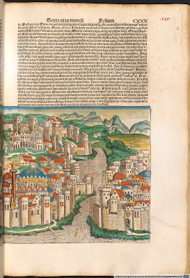
There is only one map of Istanbul I know of that shows the chains of the Golden Horn.  I'm sure there are others, but this one comes from the Liber Chronicarum (Book of Chronicles) by the German historian and cartographer Harmann Schedel.  Better known as the Nuremberg Chronicle, the book is a history of the world; yes, from the Genesis all the way to the time of its publication in 1493.  I wouldn't be surprised if Schedel's Chronicarum were the first printed urban history, as the book includes descriptions and illustrations of something like sixty cities (with various degrees of verisimilitude.)  The woodcuts (more than 1,800 in total!) came from Michael Wolgemut, a painter and printmaker that ran a large workshop in Nuremberg (the young Albrecht Dürer was an apprentice of in Wolgemut's workshop during the years preceding the publication of the book, so it's not inconceivable that some of the images may have come from Dürer's own hand.)

Schedel chronicles the 1453 fall of Constantinople to armies of the Ottoman Sultan Mehmed II, fresh news at the time, you could say.  Folio 130 includes a double spread map--more like a frontal perspective--of Constantinople with a great deal of detail.  If you look towards the bottom of the right page, you can see not one but two chains anchored to the fortifications surrounding Hagia Sophia (unmistakable in the sheer size of the dome) and then dipping into the waters of the Golden Horn.  One is almost at the point where the estuary opens to Bosphorus and the other further inland.


Monday, November 26, 2012

Urban Chains


Providence, November 26, 2012

Many cities at one point or another in their history built large fortresses, walls--on land and sea--and other major, often enormous defensive constructions.  But I can think of only two cases in which the defensive enclosure went all the way to the water: Havana and Constantinople.  The importance of both cities was connected with their crucial strategic position in transcontinental routes and their natural defensive conditions, the deep bay of Havana and the Golden Horn of Constantinople.  Now, how do you defend the actual entrance to these heavens?  After taking control of Constantinople in 717, the Byzantine Emperor Leo III, came up with the idea of closing the entrance to the Golden Horn with a gigantic chain floating on barrels and anchored on the Tower of Eugenius on the Eminönü side (the historic peninsula) and to the Kastellion on the Galata side.  Can you imagine the elaborate, almost theatrical production involved in pulling the chain, an artifact of geographic scale, across the waters of the Golden Horn?  Similarly, the entrance to bay of Havana, in Cuba, was protected by two fortresses--El Morro on the east side and La Punta on the west--and every night at nine o'clock, the sound of a cannon would indicate the time to pull a chain of large wooden links from one side to the other.  The city was closed for business.


Sunday, November 25, 2012

Merian Map, the People of Paris


Cambridge, November 25, 2012

It seems that maps are very good at depicting land masses, rivers, streets, squares, parks, gardens, buildings, bridges, defensive walls and other physical aspects of the city.  But what about people?  Well, if you look at building patterns and manage to identify the residential fabric, it's possible to get a sense of the way people live in a city.  It's quite evident that at the time of the Merian map (again, 1615) Parisians lived in a compact--urban we could say--manner.  Although the population of Paris had reached a quarter of a million by the 1550's, the civil and religious wars that ensued, quickly brought the number down to little more than 200,000.  Remember the St. Bartholomew's Day massacre?  Just during those weeks in the summer of 1572, Paris lost thousands of people, maybe tens of thousands!  In any case, the walls depicted in the Merian map encircled about 450 hectares (less than 2 square miles) so the population density would have been something like 120,000 inhabitants per square mile!  Today, the population density of Paris is less than half.  And if you want to be really impressed, only a couple of decades later, at the height of Richelieu's power, the population of Paris doubled... and the area remained virtually the same.  That's a lot of people in a rather small place, don't you think?

But our engraver has a more direct way of showing the population of Paris on the map: he simply bookends the large view of the city with two rows of small vignettes, literally depicting the people, very "properly," men on one side, women on the other and, even more "properly," distinguishing social classes, from top to bottom, the king and queen, the aristocracy, the bourgeoisie and the commoners.

Saturday, November 24, 2012

Merian Map of Paris (more about the city walls)


Becket, November 24, 2012

Paris was a walled city for much of its history.  Other than for the last hundred years or so (let's say that the absurd Ligne Maginot completed in 1939 was 300 miles to the east so it doesn't really count as a city wall) Paris wasn't encircled by a defensive wall only between 1670--Louis XIV felt powerful enough to order the demolition of the fortifications built by his father--and 1785 when the Ferme générale began construction of an enclosure for tax purposes.

Can you picture the enormity of the resources these walls took?!

There is this beautiful map of 1615 (known as the Merian map, after its author, the Swiss engraver Matthäus Merian,) really a bird-eye view, that shows Paris as a heavily fortified city.  On the foreground, Merian actually shows two walls, an outer wall with the characteristic bastions of the period, built in the 1630's by Louis XIII, and an innner wall with a more conventional, linear profile built in the 1300's by Charles V and his succesor, Charles VI.


Yes, the demolition of these walls opened the area for the construction of the first great generation of Parisian Boulevards, Louis XIV's Nouveau Cours built between 1668 and 1705.

Wednesday, November 21, 2012

Paris "Mur-murant"


Becket, November 21, 2012

Imagine this: it's early spring in 1814 and Napoleon's "grand tour" is coming to an end; if you are in Paris and look north, you can see the troops of Tzar Alexander atop the hills of Montmartre.  This image of foreign armies--not only Russian but also Prussian and Austrian--entering triumphantly in Paris is not going to be easily forgotten.  It must have certainly been in Louis-Philippe's mind when he first thought about surrounding the city with a protective wall-- known as the Thiers Wall after the prime minister Alphonse Thiers,--the larger enclosure in this 1841 fortification map.  It run for 33 kilometers (21 miles) and encircled 7800 hectars (more than 30 square miles,) more or less establishing the shape of Paris proper, all the way to the present.

Defensive walls have had a profound impact in the shape of cities, even after they become obsolete and get demolished (just think of Vienna's Ringstrasse.) The Thiers Wall came down after WWI, but its footprint can still be traced in the Boulevards des Maréchaux and the Boulevard Périphérique.


The inner area that appears in this 1841 map is bound by the Wall of the Farmers-General, a legacy of the "Ancien Régime" built just before the revolution, not for defensive purposes but to collect taxes.  It enclosed 3400 hectars (13 square miles) and defined the extents of Paris until Napoleon III expanded the city all the way to the Thiers Wall, setting the stage for the enormous urban transformations of his prefect, Baron Haussmann.

Sunday, November 18, 2012

Loos in Paris 2


Becket, November 18, 2012

I'd love to know more about Loos during his years in Paris.  Particularly about his relationship with the avant-garde.  Yes, there are some points of connection. In 1923 he showed a number of models and drawings in the Salon d'Automne and in 1925 he designed a house for the poet Tristan Tzara, one of the founders of Dada.

Other than a couple of interiors, the house for Tzara was the only project that Loos built in Paris.  Situated on a narrow, steeply sloping plot on Avenue Junot in Montmartre, the house presents an elongated, vertical five-story façade to the street and a terraced massing to the back.  Obviously the section is a response to the topography of the site, but Loos extends this logic all the way to the front, where he divides the façade in two parts: the upper portion in rendered in plaster and the lower built in stone.  It is as if the base were a retaining wall, not unlike the one next door (of course, this is a rhetorical gesture, since the actual retaining walls are farther back.)  In a rather exquisite and daring play of scales, the architect concentrates most of the fenestration inside a pair of large, two-story recessed spaces, one at street level, as a portal framed by a thick concrete lintel, and a narrower, more vertical void on the upper floors.  Only the smaller windows on the third floor are flush with the front surface and, by aligning their sills with the top of the stone, they give the impression that the plaster sheet is sliding up from behind the stone.


(By the way, I've known and admired this house for more than three decades but must confess that only now I'm seeing its connection with the Michaelerplatz building, both with this radical division between the expressed material of the bottom--one polished marble, the other rough stone--and the plainer, more abstract rendition of the top.)

Saturday, November 17, 2012

Loos in Paris 1


Becket, November 17, 2012

Nikolaus Pevsner in 1966: "Adolf Loos remains a mystery."  And in many ways he still remains the most elusive figure of modern architecture.  Quintessential Viennese, he spends a number of years--from 1924 to 1928--in Paris.  During that time his work amounts to a series of grandiose projects with little chance of realization, such as a hotel on the Champs-Elysées, an office block with a huge cinema across from Garnier's Opera or a circular garage on the Rue de Messine.

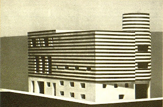
But perhaps the most fascinating of Loos's projects for Paris is the also unbuilt (and most likely never commissioned) house for Josephine Baker.  He takes two houses that Baker owns at a corner of the Avenue Bugeaud and wraps them together in a prismatic volume of alternating black and white marble stripes. He continues the banding around a taller cylindrical turret marking the entrance of the house.  Can you imagine such a radical statement among the traditional bourgeoisie of "le seizième"?


And the stripped façade is just the beginning of an elaborate game of... of hide and seek you could say, where the architect packs a series of monumental stairs, grand salons, narrow passages and hidden cafes circling around a large indoor swimming pool with windows that promise a glimpse or two of the legendary "Black Pearl", naked of course, dancing about in the water.


Friday, November 16, 2012

Vigevano's Piazza Ducale


Becket, November 16, 2012

Sorry I'm jumping from city to city, but talking about figural urban spaces I couldn't avoid thinking of Piazza Ducale in Vigevano (in Lombardy, not far from Milan.)  It's really an incredible place!  A long, narrow rectangle with  Renaissance arcades (attributed to Bramante, the great Vatican architect) ending in the concave Barroque façade of the cathedral.

And here is where the fun begins.  If you look at the façade of the cathedral, it's perfectly aligned with the long axis of the square.  Its four doors at the lower level modulate beautifully that bowed eastern end of the square.  Wait, four doors?  Yes, the building behind is a traditional church with a central nave, so which of the four is the main entrance?  I'll tell you, it's the second one counting from the right.  Actually, the first three doors from the right are entrances to the cathedral.  And the fourth door?  It's really an arch with nothing but a street behind.


But it gets even better.  The cathedral is embeded in the urban fabric behind and it's not at all aligned with the piazza, so the façade is really a paper-thin stage set with a complicated arrangement of oblique thresholds and small stairs padding the irregular leftover between the square and the church.

Talk about Barroque mise-en-scène! 


Paris in Cairo?


Providence, November 15, 2012

I'm not sure if Place des Vosges inaugurated the practice of carving urban space out of existing urban fabric, but the experience of Paris had certainly an enormous impact throughout the world.  Just look for example at a map of Cairo at the time of the ambitious modern ruler of Egypt, Isma'il Pasha (1863-79.)  The image is dominated by the dense fabric of Medieval Cairo with its characteristic irregular pattern of narrow streets.  Then, more or less on the northwest corner you see the very same footprint of Place Vendôme!  No, it's really not a square, more of an urban park, the Ezbekiya Gardens.  Still, the similarity is telling, don't you think?  Particularly when you see the most Houssmannian of avenues--at the time named after Isma'il's grandfather, Muhamad Ali, from whom he took on the modernizing impulse--reaching all the way to the oposite corner of the old city to end at the carefully shaped  square in front of the Sultan Hassan Mosque complex.  Also, between the old city and the Nile, the map begins to show the traces of a new, much more regular city of orthogonal streets with diagonals and spaces such as Midan Talaat Harb or Midan Moustafa Kamel that are not hard to relate to the circular Place des Victoires.


Tuesday, November 13, 2012

Turgot Map, Place des Victoires


Cambridge, November 13, 2012

The designer of Place Vendôme was Jules Hardouin Mansart, Louis XIV's chief architect.  He had already designed a figural urban space for Paris before, the remarkable Place des Victories, a perfect circular plan with a regular four-story facade all around.  This is a point in the city where a number of streets come together at different angles and the circle has the double task of reconciling the competing geometries and, at the same time, establishing an urban space with its own identity.  Although the buildings surrounding Place des Victoires are residential, the facades have a deliberately monumental character: a tall base of rusticated arches, the two main levels above linked by gigantic Ionic pilasters, all capped by the the characteristic Mansard roof (named after Hardouin's great-uncle François Mansard) of dark slate.  This architecture, as much as the crisp geometry of the circle, carry the difficult role of unifying a space challenged by several streets coming at it from different angles

For a few decades, the center of the Place des Victoires was rather contested.  The Turgot map shows the original monument designed by Martin Desjardins, an alegorical composition celebrating the power of Louis XIV.  At the time of the French revolution (you can guess it, right?) the monument was taken down.  In 1793 the revolutionary government erected a wooden pyramid.  In 1810 Napoleon replaced it with a statue of Louis de Saix, one of his most trusted generals, and in 1828 (towards the end of the brief Borbon Restauration) Charles X placed the equestrian statue of the Roi-Soleil that you can see today.


Monday, November 12, 2012

Turgot Map, Place Vendôme


Providence, November 12, 2012

I spoke too fast when I wrote that you woudn't find another square carved out of the fabric in the Paris of the 1730's: yes, smack  at the bottom of the map is Place Vendôme, completed in 1720, just in time for inclusion in the Turgot map.  Here we are at the height of the barroque, so the space is much more figural than the simple square of Place des Vosges.  It's a rectagle with chanfered corners and formalized entrances at its narrow sides.  It's smaller, with tighter, more intense proportions.  The buildings that line its perimeter are excedingly thin, as if the architect were relishing in the stage-set quality of his architecture.  The rectangle is aligned with Rue Saint-Honoré and the surrounding fabric simply hits the back of its architecture at odd angles.  In the Turgot map the square appears as "Place de Vendome où de Louis Le Grand".  Yes, you'll have to imagine it not with Napoleon's Trajan column (for that you'll have to wait to Austerlitz in 1805) but with an equestrian statue of Louis XIV facing south (towards Rue Saint-Honoré.)  You'll also have to wait for Napoleon to blast Rue de la Paix through the old convent of the Capucins, so for about a century Place Vendôme was a rather private space, secluded from the traffic of the city.

Sunday, November 11, 2012

Turgot Map of Paris 3


Becket, November 11, 2012

You could take any sheet of the Turgot map and look at it for hours.  I'll start with a sheet that includes one of the most remarkable places in Paris, Place de Vosges.  Labeled "Place Roiale" (of course, it changed its name shortly after the revolution,) it was barely more than a century old when Bretez drew the map.  Look at it, I'm pretty sure there is nothing like that in the whole map: a perfect square, 140 x 140 meters, with regular facades all around.  Let me try to explain what is so extraordinary about this.  At the time, everything else in the city took shape through accretion, an additive process; the Place Royale, by contrast, is the result of a subtractive operation, as if the square would have been carved with a giant knife from the older fabric and then resurfaced with a new layer of housing.  This is particularly apparent because the square aligns with the blocks to the north (left on this map) and then the other sides meet the surrounding fabric at odd angles.  With its regular rhythm, distinctive surfaces of red brick and sandstone, vaulted arcades and steep roofs of blue slate, the architecture of the square only strenghtens the distinction from its context.

The Place Royale became a favorite place of residence for the aristocracy right away.  Cardinal Richelieu moved there soon after the construction was completed.  He was the one that put the equestrian statue of Louis XIII in the center (no, the statue standing there now dates from the early 19th century; the original one, like so many other monuments in Paris, you can guess it, was taken down and melted at the time of the revolution.)  The list of notables that called Place de Vosges home at one time or another also includes Victor Hugo, Madame de Sevigné, Théophile Gautier and Alphonse Daudet.

(Sorry flaq, that was again something like 300 words, but I couldn't resist mentioning some of the people that lived there.)


Saturday, November 10, 2012

Turgot Map of Paris 2


Becket, November 10, 2012

As I told you yesterday, the Turgot map of Paris has an incredible amout of detail.  What in the Stockdale map (the 1800 English map I wrote about before) are hatched blocks, here appear as carefully rendered buildings, drawn one by one with minute detail.  There are many rows of individual narrow buildings with pitch roofs facing the street.  Almost as many ribbons of buildings with pitched roofs parallel to the street.  The blocks are compact, with very small courtyards.  The overall mass is four-to-six stories high, the ground level with larger openings and the roofs with dormers and other small windows indicating an extra habitable level.  Blocks tend to be rectangular, some very narrow and elongated, others much wider.  The streets appear narrow and straight, mostly forming a grid pattern.  There are some larger open spaces inside wider blocks, some simply leftovers and others formalized as courtyards.  The fabric is dotted with monumental buidings, churches, etc. with distinctive profiles but still embeded in the overall mass of the blocks.

The draftman of the Turgot map was a certain Louis Bretez, that took two years--from 1734 to 1736--to measure buildings and open spaces and to draw the 21 sheets (twenty depicting the different areas of the city and one with a more schematic overal view) of the map.  After Bretez completed his work, the engraver Claude Lucas produced brass plates for printing.  The bound volumes of the Turgot map were first published in 1739.  The plates are kept in the Louvre and are still used for ocassional re-printing.


Turgot Map of Paris 1


Becket, November 9, 2012

Flaq,

Looking through maps to write about, I found this amazing one of Paris!  The  "Plan de Turgot", first published in 1739.  Yes, roughly contemporary to the famous "Nolli" map of Rome and at least as involved.  The Turgot map--named after Michel-Étienne Turgot, the "prévôt des marchads de Paris" (the major) that  comissioned it--is really an atlas of 20 plates covering the historical core of the city (roughly the area of the first eight present-day arrondisements) and the "fabourgs" that would later develop as the next ring of arrondisements (nine to eleven.)  Each sheet is a rectangle 50 by 80 cm, so if you were to assemble them together, the whole thing would be something like 8 x 10.5 feet!  It's really not a true plan but more of a bird's eye view.  Technically speaking it's an oblique projection (a parallel projection, not a perspective with vanishing points) so everything is drawn to scale.  It must have required an enormous amount of information, since it depicts each and every building down to the facades, windows and roofs.  I suspect that it would have been a rather old-fashion way of drawing a city map even the time (this kind of projection was called "cavalier projection" and was originally developed for military purposes.)

Yes, plenty to look at and write about in this map.  Certainly more than enough for the next week or so while you're in Paris.

Papá


Stockdale Map of Paris 3


Cambridge, November 4, 2012

One last entry about the 1800 Paris map flaq.  At least for now.  About the inside, the outside and the boundary.

These days it woudn't be easy to put a finger on a map and say "here, this it where the city ends."  Or if you did, you'd be pointing at a rather blury edge that most likely is shifting rapidly.  Perhaps the end of the 18th century was the last time you could do that.  The traces of defensive walls were still there one way or another.  Our map shows a clean poligonal line with two rows of trees encircling the core of the city.  At some points--such as the Bastille and the Arsenal to the east--it even has traces of the characteristic renaissanse bastions with their angular geometries.

Inside the boundary, mostly a dense mass of irregular blocks tighly hatched to indicate a dense built fabric with narrow streets.  Outside mostly, dotted lines, little circles and other lighter marks depicting a rural landscape, farms and gardens.  But there are some hatched  ribbons outside of the line--particularly to the northwest and northeast--already linning the streets that radiate towards the larger city of the 19th century.  The first eight Arrondissments of Paris are clearly in place and the next four (9 to 12) are pretty much on their way.

Stockdale Map of Paris 2


Becket, November 2, 2012

Sorry flaq, skipped a couple of days.  Back to the map.

In a current aerial of Paris it's very easy to identify the Louvre--actually the continuos axis that goes from the Cour Carée just west of the Pont Neuf all the way to the Place de la Concorde (and even farther along the Champs-Élysées to the Arc and beyond)--but in this 1800 map there is a whole lot of stuff, irregular fabric, between the large square of the palace and the Tuileires.  And there is no Grand Palais (or Petit Palais for that matter) that will have to wait another century to be built.  While looking at the area, I notice that the octagon of La Concorde is labeled "Lewis the XV. Place", which tells you that our English draughtsman is copying a map dating from before the revolution, before the statue of Louis XV standing on his horse was replaced by the guillotine used to behead Louis's unfortunate grandson in 1793.

The Tuileries is one of several large rectangles of axial composition that already appear in this 1800 map.  Just on the other side of the river are Les Invalides and the Ecole Militaire, also recognizable in their regular geometry of monumental buildings and open spaces.  In the case of the last one, the Champ de Mars ends in an island that by 1800 was already annexed to the Rive Gauche that would provide the ground for the Eiffel tower in almost a hundred years.  A the time, these figures were at the edge of the city, although now are very much embedded into the fabric and appear as distinctive large voids.

Woops, almost 300 words.  Oh, well, it compensates for not writing yesterday or the day before.

Stockdale Map of Paris 1


Cambridge, October 30, 2012

Flaq,

Maybe I'll take advantage of our 200-word deal to write about maps.  Definitely good for my "Reading the City" project.  Where to begin?  How about Paris?

I have in front of me an English map of Paris from 1800.  An interesting date; about a decade after the fall of the monarchy and a good half century before Haussmann crisscrossed the city with his boulevards.  It shows an almost perfect circle of densely built irregular blocks traversed east-west by the Seine.  Smack in the center is the "Isle du Palais" (the Île de la Cité) and running north-south, the only major straight uninterrupted street, "St. Martin" to the north and "St. Jacquae" to the south.  Later displaced by larger boulevards (de Sébastopol and Saint-Michel respectively,) that line dates back to the Cardo Maximus of Lutecia, the Roman foundation of Paris.

If I'm getting the scale right, the circle depicted in the map has a diameter of approximately 15,000 feet, about 3 miles (let's say from Les Invalides to the Bastille, does it seem right?)  With a population of a little more than half a million people at the time, it would put Paris at more than 70,000 inhabitants per square mile.  That's the density of Manhattan today!  Incredibly, isn't it?

Yes, lots more in that map.  I'll go back to it tomorrow.

Papá